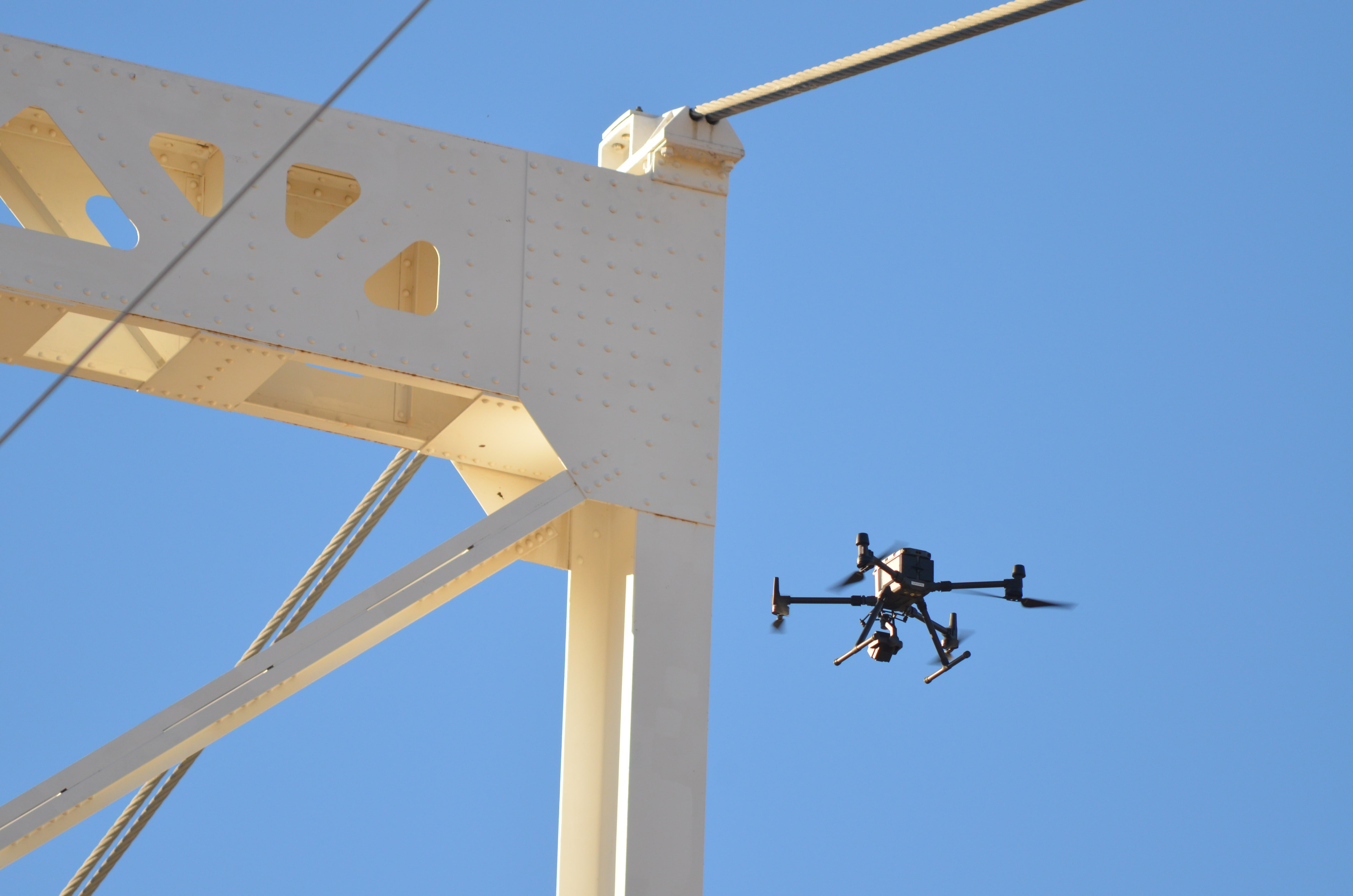
HALKIN AERIAL DRONE & UAV SERVICES
Originally founded in 1982, Halkin’s certified technicians, inspectors, pilots, and software engineers have been providing testing, inspection, and reporting services for 40 years. The industries we have served include petrochemical refining, energy infrastructure, industrial facilities, commercial buildings, and agricultural enterprises. All our inspection reports are generated and delivered on our proprietary software platform called SeraPoint. SeraPoint is a visual, geo-referenced, highly collaborative, 3-dimensional scale rendered modeling platform initiated by advanced, automated drone flights. SeraPoint provides design, measurement, reporting and collaborative functions in a scale-rendered, geo-referenced, virtual environment. Our patented “geobrowser” makes SeraPoint the first platform capable of using advanced, automated drone flights to bring any property to your fingertips in scale renderings accurate to within 1 inch. Our clients can invite an unlimited quantity of users to their secure, private portal for customers, prospective customers, vendors, contractors, investors, or co-workers. SeraPoint is also used to create As-Built drawings through advanced automated drone flight programming.
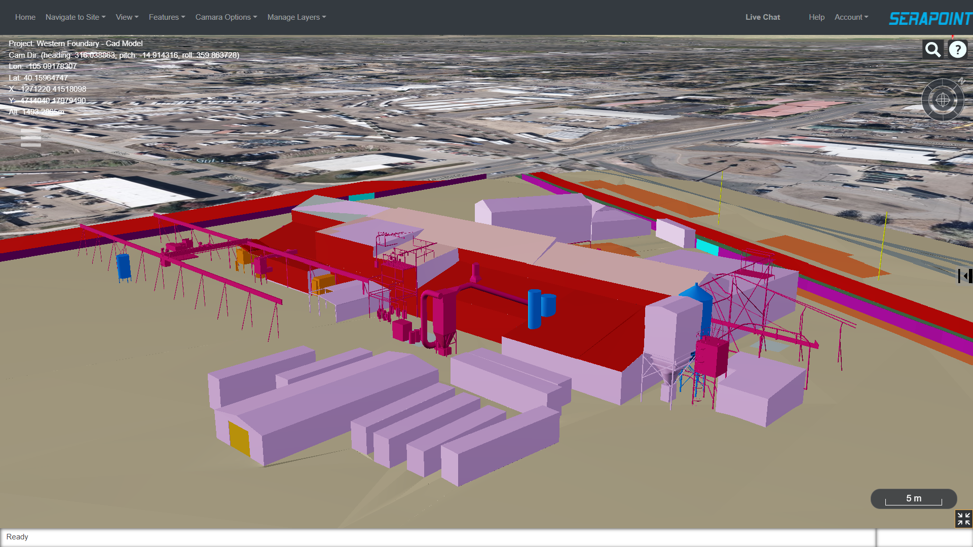
CEO
Grant Hall is Managing Director of Halkin Aerial Services with focus on coordination of division heads, business development, and strategic planning. In his current role, Grant negotiates 3rd party technology transfer, sets direction for internal technology improvement / expansion, participates in business development activities and market segment expansion, and oversees day-to-day business operations.

OUR SERVICES

DRONE ASSET INSPECTION
As well as using drones to inspect specific assets, Halkin also has experience working with asset management clients for large scale and ongoing asset monitoring and maintenance programs. SeraPoint offers more than just a drone flying service with qualified staff with decades of experience. Many of our clients provide SeraPoint with an asset register and inspection specification and let us manage the inspection works on an ongoing basis, either capturing the data for their own analysis or where appropriate independently reporting and highlighting any issues needing attention. Halkin's SeraPoint online inspection data platform can be used to host the visual inspection imagery and 3D models, and we can also use or integrate with your own internal or 3rd party asset management systems.’

SURVERY & MAPPING
Unmanned Aerial Vehicles (UAVs) technology has been around for nearly a century, but it certainly wasn’t used in the way we see them used today. As the technology continues to evolve, HALKIN continues to stay in step with the ever-changing scope. At HALKIN, we use unique skills and advanced equipment to bring customers a first-class aerial surveying and mapping experience. HALKIN strives to provide superior quality aerial drone surveying and mapping services with highly accurate topographic maps and centimetre-level accuracy at any given time. The resolution of our maps and survey data is usually between 1- 3cm per pixel (1-3cm GSD). We process the data to deliver full 3D terrain models (e.g., DSM, DTM), and the accuracy of the 3D data is generally around 50mm horizontal and 50-80mm vertical.

AERIAL LIDAR
LiDAR (Light, Detection and Ranging) refers to a method of survey data capture whereby a laser is reflected off an object and the response time to the return sensor enables the calculation of the distance. HALKIN have prepared a detailed comparison of the difference between drone aerial LiDAR surveys and those captured using photogrammetric methods. Data capture with a drone-based LiDAR is more expensive than that completed with photogrammetry, mostly due to the costs of the sensors and drones that are required to carry them. Where LiDAR comes into its own is where there is dense vegetation as the laser pulse will be more able to reach the ground compared to the photogrammetry derived survey model. For more information on asset inspection in your specific area of interest, contact us to discuss your needs.

AERIAL PHOTO & VIDEO
Drones are inherently mobile and have the innate ability to capture on-demand maps at a cost much lower than traditional approaches that involve manned aircrafts. Moreover, the drone imagery is of much higher resolution than satellite or ground-based capture. Since 2013, HALKIN has offered reliable, high-quality drone services, aerial mapping and accurate survey data for CBAYCO, Denver, and elsewhere around the country.

THERMAL SURVEYS OF SOLAR FARMS
A solar farm – also known as a solar power plant or solar field – is a large-scale installation of solar panels or PV systems designed to generate electricity from sunlight. A solar farm typically consists of thousands of solar panels arranged in rows or arrays on a large piece of land. These panels have solar cells that capture the sun’s energy and convert it into electricity, which can then be distributed to the power grid or stored in batteries for later use. To ensure your renewable energy plant is operating at its best, it needs to be properly maintained – any kind of damage to core components can cause a ripple effect that impacts a large portion of the entire farm. At HALKIN, we utilise drone technology to perform solar farm inspections that can provide all the necessary data to keep your solar assets in check.

SENSORS & SERVICES
Whilst the vast majority of our work is associated with capturing images of LiDAR data to create 3D representations of structures or terrain, we have many other solutions we can offer. Drones are a tool that can carry a wide range of payloads to complete an array of applications. Our team of technical specialists have decades of combined experience and enjoy the challenge of solving problems. If you would like to sense test an idea please contact us to discuss what you have in mind.
Success Story
5151 Bannock
A dense area of large buildings for inspection has been done by HALKIN.
Cultivation area survery of CBAYCO on a large scale with residance buildings.
CONTACT
Email
info@serapoint.com
Phone
303-846-3094
Address
10908 E Crestridge Circle Englewood, CO 80111
ABOUT
News
Careers With Halkininc
Locations
Privacy Policy
Sitemap
Terms & Conditions
SERVICES
Drone Asset Inspections
Aerial Survey & Mapping
Aerial LiDAR
Terrestrial Laser Scanning
Aerial Photo & Video
Roof & Building Inspections
Thermal Surveys
Crack Mapping of Dams
Distribution Pole Inspections
DATA SYSTEMS
Drone Data
SeraPoint